Street Calls of the Week
In a significant stride for global scientific collaboration, Geoscience Australia, the US Geological Survey (USGS) and the Geological Survey of Canada have unveiled a consolidated compilation of national-scale geological, geophysical and mineral resource datasets in a bid to unify critical minerals data.
This landmark initiative stands to augment scientific investigations and foster deeper insights into critical mineral research for Australia and its partner countries.
Dr Anne McCafferty of the USGS articulated the essence of this initiative, stating, “geology doesn’t stop at the border and neither does our data”.
She further remarked on the implications of this shared data, noting, “Scientists will now be able to look at geological and geophysical data seamlessly across both Canada and the United States as well as make direct comparisons to Australia.”
Closer to home, Dr Karol Czarnota of Geoscience Australia spotlighted the transformative potential of these datasets, indicating that they "enable unique investigations into the controls on critical mineral distribution which were simply not possible beforehand”.
What is in the data?
Released as a pivotal part of the critical minerals mapping initiative (CMMI), the data comprises more than 40 layers of intricate earth science information.
Notably, it includes a map detailing the Earth's natural magnetic field variations across North America, a tool poised to be instrumental for researchers aiming to craft three-dimensional models of subterranean geology.
Conforming to universally accepted geographic information system formats, these datasets have been meticulously curated by Geoscience Australia, the Geological Survey of Canada and the USGS.
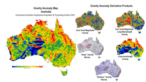
Unified geophysical datasets for Australia as part of the critical minerals mapping initiative.
Advanced analytical techniques
The overarching aim of the CMMI is a confluence of expertise from the three geological surveys.
The initiative seeks to deepen understanding of critical mineral resources, shed light on geological controls governing the distribution of key deposits, pinpoint potential new mineral sources and further critical mineral research across Australia, Canada and the US.
Beyond its immediate geological applications, this unified data is pivotal for broader applications, including natural hazard assessment across the collaborating nations.
The datasets are also proving instrumental for advanced analytical techniques, with machine learning applications already in play.
For instance, using the unified datasets, a CMMI-led team has identified potential sites in the three countries renowned for specific zinc deposits, which are also rich in other essential minerals.
