Riversgold Ltd (ASX:RGL) has revealed that a geological mapping and rock chip sampling program at its newly granted Wodgina East Project (E45/6363) confirmed channel iron mineralisation in several mesas.
Wodgina East is immediately adjacent to the Wodgina Lithium Mine and in the vicinity of numerous known iron ore deposits and mines.
It is just 120 kilometres south of Port Hedland along the Great Northern Highway, which runs north-south through the southeast corner of the tenement.
"Highly encouraging"
Riversgold chairman and CEO David Lenigas said: “The iron potential from these mapped channel iron mesa deposits is highly encouraging and we look forward to conducting further work to verify the iron grades returned from the historical samples and APEX sampling to date.
“Iron ore is a good place to be now and these mesas look very attractive for potential development, especially considering that the project is ideally located next to the major highway that runs through to Port Hedland and is only 114 kilometres to the Utah Point multi-client terminal at Port Hedland.
"This close proximity of the channel iron deposits (CIDs) to Utah Point makes trucking from project to port attractive.”
Potential channel iron deposits
Riversgold has completed its Phase 1 reconnaissance exploration program at the Wodgina East Project, identifying several potential channel iron deposits.
The company engaged APEX Geoscience Ltd to carry out the geological mapping and rock chip sampling program to assess the project’s potential for channel iron deposits.
Field observations from the APEX team suggest potential for a series of large, mesa-forming, channel iron deposits occurring in the south of the Wodgina East property within one kilometre either side of the main bitumen highway.
Detailed geological and satellite imagery mapping of the area has delineated two erosional-resistant mesas extending over 1.5 kilometres long.
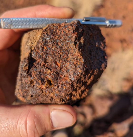
One of the mesas is capped by a hard, goethite-hematite, pisolitic (to oolitic) clastic sedimentary unit, interpreted to be physically transported iron derived from the erosion of laterite hardcap.
The clastic iron fragments are cemented by iron oxides. This unit is labelled 'Robe River pisolite'.
Review of historical open-file exploration data shows that Mesa 2 returned eight rock chip samples, collected by Hemisphere Resources in 2011 and 2012, ranging from 51.94% to 56.67% iron.
Riversgold is planning an infill and extensional sampling program along with metallurgical bulk sampling to determine beneficiation potential.
Robe River pisolite hand sample located from Mesa 3 (200m west of tenement boundary) showing representative Robe River pisolite found on Mesa 1 and Mesa 2.
Read more on Proactive Investors AU
